Overview
The Rif is northern Morocco's great mountain range — a curved arc of peaks running roughly parallel to the Mediterranean coast from Tangier in the west to the Moulouya river in the east. It is geologically separate from the Atlas and culturally distinct from the rest of Morocco: the Rif is the heartland of the Amazigh Riffian people (Irifen), who speak Tarifit (the northern Berber dialect) and have maintained a fierce independence that produced the legendary Republic of the Rif under Mohammed Abd el-Krim in the 1920s.
The landscape ranges from deep limestone gorges and swift mountain rivers to dense forests of cedar, cork oak, and fir — some of the last significant Mediterranean forest cover in North Africa. Above 1,800 metres, the terrain opens into rocky ridgelines with views north to the Mediterranean and south over the vast Moroccan interior.
For most visitors, the Rif means one thing first: Chefchaouen. But the town is the beginning of the region, not the whole of it. The Talassemtane National Park, the Akchour gorge, the Jebel Tissouka massif, and the largely overlooked city of Tetouan all reward the traveller who spends more than a day in the mountains.
How many days do you need in the Rif?
Choose the trip by what you want to do, not by how many sights you can collect. Travel is by road and mountain journeys take longer than the map suggests.
| Time available | Best plan | What it gives you |
|---|---|---|
| 1 night | Chefchaouen only | An evening and early morning in the medina, plus the short Spanish Mosque walk. |
| 2 nights | Chefchaouen + Akchour | One full day for either the waterfalls or God's Bridge without rushing your arrival and departure. |
| 3 nights | Chefchaouen + one mountain day + Tetouan | A balanced northern trip combining the blue medina, a trail day, and Tetouan's UNESCO-listed medina. |
| 4+ nights | Add a summit hike or slower northern circuit | Enough margin for weather, a licensed guide, and onward travel through Tangier or Asilah. |
Chefchaouen
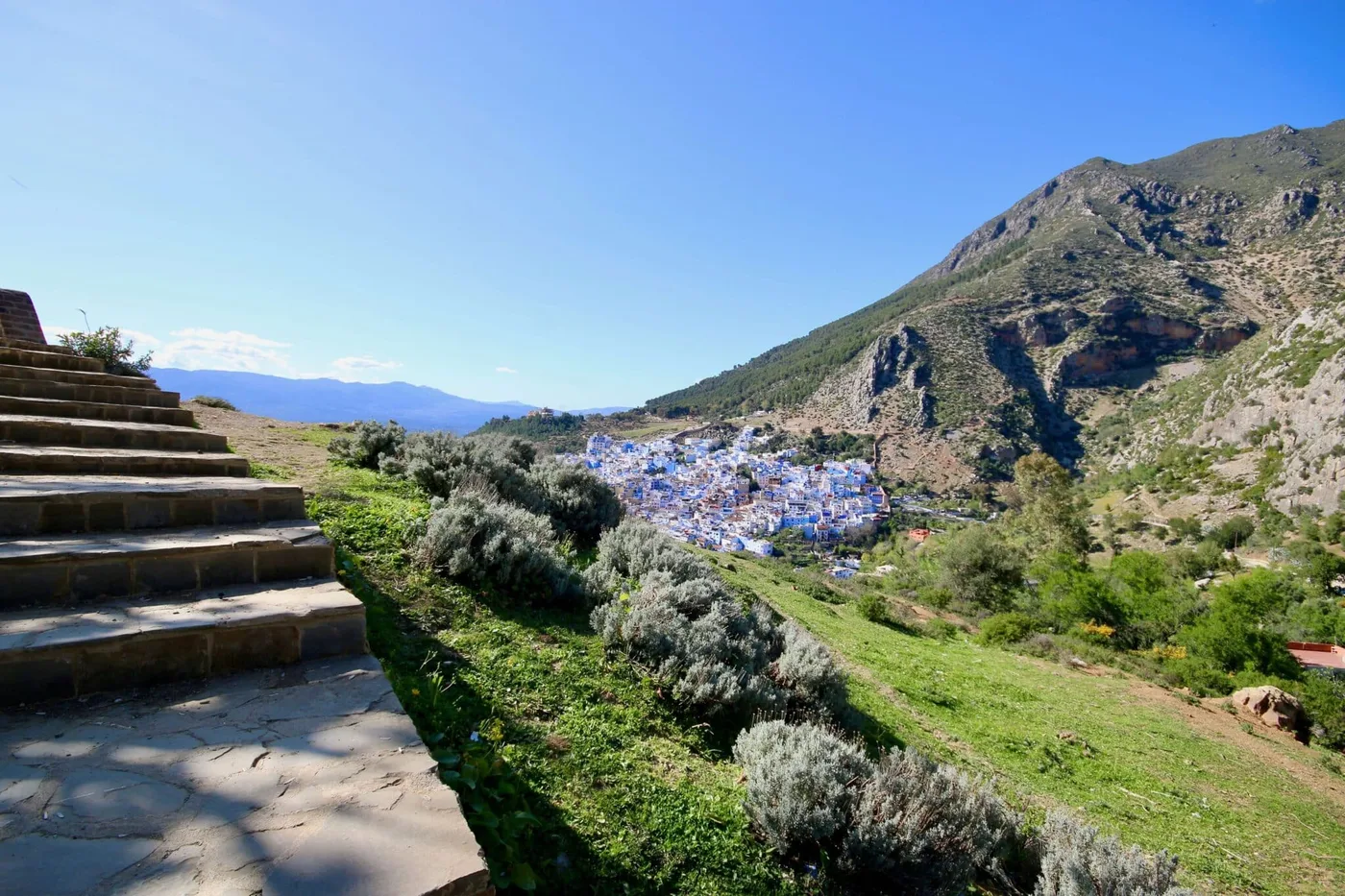
Chefchaouen sits in a valley of the Rif at around 600 metres, its blue-washed medina climbing the hillside in shades that shift from pale sky to deep indigo depending on the light and the hour. It is Morocco's most photographed town and, despite the crowds, still one of its most rewarding — particularly if you stay overnight and experience it after the day-trippers have left.
Founded in 1471, Chefchaouen was largely closed to non-Muslims until the 20th century, and the relative isolation preserved both its architecture and its distinctly Riffian character. The medina is compact and walkable — Place Uta el-Hammam at its centre, the Kasbah and its Andalusian garden at the square's edge, and the Ras el-Maa spring at the top where the town meets the mountain.
The town is the natural base for exploring the surrounding Rif — most hiking routes start from or near the medina, and the guesthouse owners are well-connected with local guides.
Akchour & Talassemtane National Park
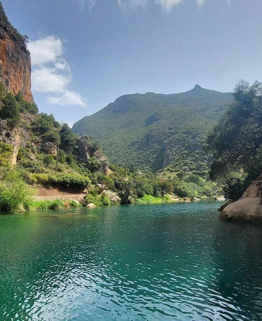
Twenty-five kilometres northeast of Chefchaouen, the Talassemtane National Park protects one of the most significant areas of Mediterranean forest remaining in Morocco — a mix of Moroccan fir (Abies marocana, found almost nowhere else in the world), cedar, and cork oak, cut through by the Oued Farda river and its tributary gorges.
The main visitor destination within the park is the Akchour area, reached by shared or private grand taxi from Chefchaouen. Confirm whether the quoted fare is per seat or for the whole taxi, and agree on your return plan before leaving. Two main trails lead from the parking area:
- God's Bridge (Pont de Dieu) — a natural rock arch spanning the gorge, reached by a moderate 2-hour round-trip hike through limestone scenery. The bridge itself is a dramatic geological formation; the gorge walls rise steeply above it.
- Akchour Waterfalls — a longer hike (4–5 hours return) following the river upstream past swimming holes and through increasingly wild gorge scenery to a series of cascades. The water is cold and clear; swimming at the pools below the falls is possible in summer.
Download an offline map before leaving Chefchaouen because reception can be unreliable in the gorge. Trail conditions change with rain and river flow; ask locally before setting out. A licensed guide is the safer choice for Jebel Tissouka, unfamiliar routes, or poor visibility.
Hiking Routes
The Rif offers some of the best mountain hiking in northern Morocco, largely undiscovered by the international trekking community that has found the Atlas. The three main hikes from Chefchaouen:
| Route | Typical time | Effort | Choose it for |
|---|---|---|---|
| Spanish Mosque circuit | 1–1.5 hours | Easy | A short viewpoint walk from the medina. |
| Jebel El Kelaa | 4–5 hours return | Moderate | A half-day summit with broad Rif views. |
| Jebel Tissouka | 7–8 hours return | Demanding | A full mountain day with a licensed local guide. |
| Akchour waterfall trail | 4–5 hours return | Moderate | River and gorge scenery; conditions depend on water levels. |
Jebel El Kelaa (1,616 m)
The most popular summit hike from Chefchaouen — a 4–5 hour return trip starting near Ras el-Maa at the top of the medina, climbing through cedar and fir forest to the rocky summit. Views extend across the Rif ridgelines and, on clear days, to the Spanish coast and the Rock of Gibraltar. No technical difficulty; a good trail throughout. Best done with a local guide for the first time.
Jebel Tissouka (2,122 m)
A more demanding full-day hike to the Rif's most prominent summit above Chefchaouen — a 7–8 hour return trip requiring a guide and good fitness. The route climbs through forest to open limestone ridgelines, with the best panoramic views in the region from the summit. Snow is possible November–April; check conditions before attempting.
Spanish Mosque Circuit
A shorter, easier walk (1–1.5 hours) suitable for all fitness levels — from the medina up to the derelict Spanish Mosque on the hill above, following the ridge for views over Chefchaouen and the valley, then descending by a different path. This is the walk that produces the classic elevated photograph of the blue medina. Best done at sunrise or in the late afternoon golden hour.
Tetouan
Tetouan is northern Morocco's most underrated city. UNESCO describes its medina as one of Morocco's smallest but most complete, with a largely intact urban fabric and clear Andalusian influence. Rebuilt by Andalusian refugees after the Reconquest and later developed under Spanish protectorate rule, the city has a visual character distinct from Morocco's larger imperial medinas.
The Royal Palace square at the medina's main entrance is one of the grandest civic spaces in northern Morocco. The Archaeological Museum and the Ethnographic Museum in the kasbah are both worth an hour each. The medina market is a working local market with almost no tourist pressure — the most authentic souk experience in the north.
Tetouan is 1 hour north of Chefchaouen by grand taxi and 40 minutes from Tangier — ideal as a stop between the two cities or as a half-day excursion from Chefchaouen.
Getting there
To Chefchaouen: No train service and no airport — buses are the standard option. CTM and local operators connect from Tangier (~2h), Fes (~3h 30min), Casablanca (~5h 30min), and Rabat (~4h). The bus station is about 1 km below the medina — walkable uphill or a short petit taxi ride. Grand taxis from Tangier via Tetouan are faster but fill irregularly.
By car: From Tangier, the A4 motorway south to Tetouan, then the N2 mountain road southeast to Chefchaouen (~2h). From Fes, the N8 west via Taounate and Ouezzane (~3h 30min). The mountain roads are well-surfaced but winding — slower than the distance suggests. Parking is available outside the medina gates.
From Spain: Tarifa ferries arrive at Tanger Ville in the city, while Algeciras services generally use Tanger Med, east of Tangier. Continue by bus, grand taxi, or hire car to Chefchaouen. Check the operator and arrival port carefully because “Tangier” and “Tanger Med” are not interchangeable.
To Akchour: Grand taxis from Chefchaouen to the trailhead village (Ain Tissimane) run when full — morning departures are most frequent. Return taxis can be scarce in the afternoon; arrange a pick-up time with your driver or carry the number of a reliable taxi contact from your riad.
Practical tips
- Best time: March–May and September–November offer the best conditions — mild temperatures (15–22°C in Chefchaouen), clear skies, and the most photogenic light on the blue medina. Summer (June–August) is warm (25–28°C) and very busy; the daytime medina is crowded but evenings remain atmospheric. Winter (December–February) brings cold, occasional mist, and snow at higher altitudes — the Jebel Tissouka hike is not advisable without winter kit.
- Altitude and temperatures: Chefchaouen sits at 600 m — noticeably cooler than the coast or the plains. Evening temperatures drop significantly even in summer. Higher hiking routes (above 1,500 m) are cold in the morning and after dark year-round. Always bring a warm layer, even when the forecast looks mild.
- Guides: The Bureau des Guides in Chefchaouen is the official point for booking licensed mountain guides. For Jebel Tissouka and multi-day routes through the national park, a guide is essential. For shorter walks (Spanish Mosque, Ras el-Maa, Jebel El Kelaa) an experienced independent walker can manage with a good map.
- Water: Do not rely on untreated surface water. Carry enough drinking water and, for longer routes, a filter or purification method. River flow and swimming conditions at Akchour can change quickly after rain; follow local warnings and keep out of fast or discoloured water.
- Photography: The Rif is spectacularly photogenic — but ask before photographing people, especially women. Residents of Chefchaouen's medina are largely tolerant given the volume of cameras, but courtesy matters. The Spanish Mosque and Jebel El Kelaa summits offer the best landscape shots; morning light (7–9am) on the medina is the classic shot.
- Combining the Rif: Chefchaouen–Tangier–Asilah is the classic northern circuit: the blue mountain town, the cosmopolitan strait city, and the elegant Atlantic port. All three are within 2 hours of each other by road or bus. Add Tetouan and the circuit covers the full range of what northern Morocco offers.