Overview
The Atlas Mountains run diagonally across Morocco for over 2,500 kilometres, forming the spine of the country and the natural barrier between the Mediterranean-influenced north and the Saharan south. The range divides into three distinct chains: the High Atlas (the tallest, containing Toubkal), the Middle Atlas (forested, cooler, with cedar and lakes), and the Anti-Atlas (older, drier, running toward the desert).
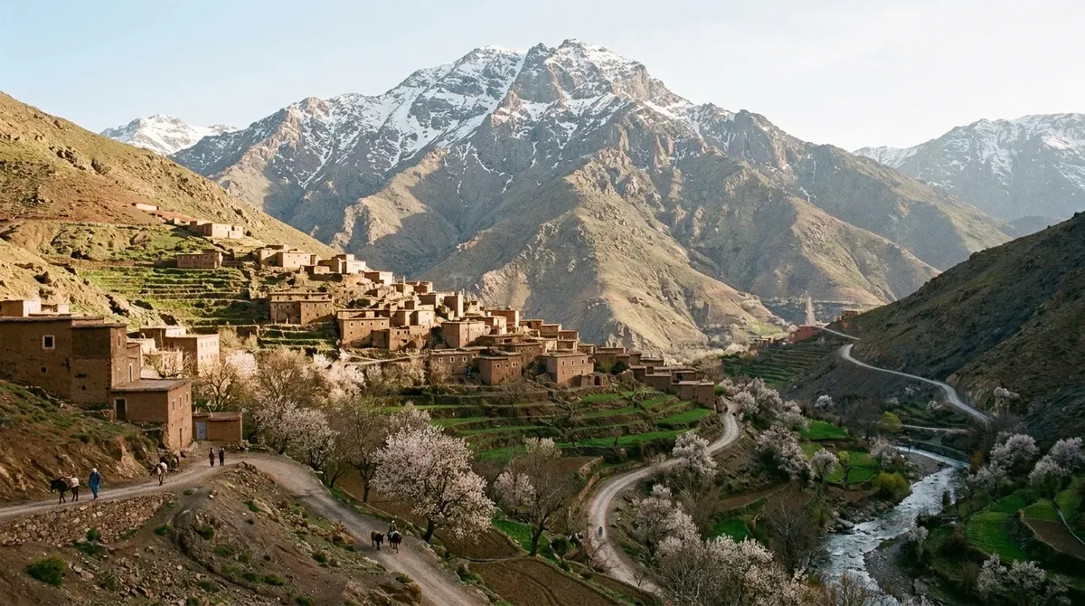
For most visitors, the Atlas means the High Atlas south of Marrakech — a world of dramatic valleys, Berber villages clinging to hillsides, terraced barley fields, and ancient mule tracks connecting communities that have changed little in centuries. The proximity to Marrakech (under two hours) makes it one of the most accessible high mountain environments in the world.
The range also forms a cultural divide. The mountains are the heartland of Morocco's Amazigh (Berber) population — the country's indigenous people, whose language (Tamazight), architecture, and customs remain distinct from the Arab-influenced cities of the plains. Visiting the Atlas is as much a cultural encounter as an outdoor adventure.
Toubkal Summit
Jebel Toubkal (4,167 m) is the highest peak in North Africa and one of the most accessible high-altitude summits on the continent. The standard two-day ascent requires no technical climbing equipment — it is a demanding but non-technical hike that fit walkers with mountain experience can complete. The starting point is Imlil, a small village 70 km south of Marrakech that has organised trekking for decades.
The typical itinerary: Day 1 — hike from Imlil (1,740 m) to the Toubkal Refuge (3,207 m), a four-to-five hour walk through the Aremd valley and past the hamlet of Sidi Chamarouch. Day 2 — summit (approximately 3–4 hours from the refuge, returning to Imlil by afternoon). The summit rewards with views across the entire High Atlas chain and, on clear days, to the Saharan plains in the south.
Snow covers the upper slopes from November through May. Crampons and ice axes are required for the winter ascent — check conditions before booking a winter trip. The summer ascent (July–August) is snow-free but hot on the lower sections and cold at the summit; bring layers.
Berber Villages
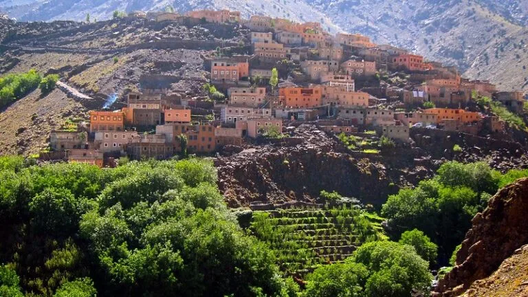
The valleys around Imlil are dotted with Amazigh villages that can be visited on foot or by mule. Aremd, perched above the valley floor at 1,900 m, is one of the most visited — its flat-roofed stone houses, communal water channels, and views toward Toubkal are the visual shorthand of the High Atlas. Tacheddirt and Ouaneskra are quieter alternatives for those wanting to walk between villages with a guide.
Many villages offer basic gîte accommodation — simple rooms in local homes, meals of tagine and bread, and the opportunity to interact with families living the same mountain subsistence that has sustained these communities for centuries. Staying overnight in a village rather than returning to Marrakech changes the experience entirely.
Ourika Valley
The Ourika Valley is the most accessible Atlas excursion from Marrakech — a road follows the Ourika river south into the mountains through a string of villages and roadside markets. The valley is green and dramatic, the terraced fields dropping steeply to the riverbed.
The main draw is the Setti Fatma waterfalls at the head of the valley — a series of seven cascades reachable by a 30-minute hike above the village. The lower falls are easily reached; the upper series requires more scrambling. The village itself has a Sunday souk that is one of the most authentic weekly markets in the Marrakech region.
The Ourika Valley is also the site of some of the best argan and saffron cooperatives in the country — stops en route are worthwhile if you want to buy genuine products directly from producers rather than souvenir shops.
Aït Benhaddou
Aït Benhaddou is one of Morocco's most dramatic and recognisable sights — a fortified ksar (fortified village) built entirely of pisé (rammed earth), rising in towers above the Ounila river on the south side of the Atlas. It sits on the ancient caravan route between the Sahara and Marrakech, and has been a UNESCO World Heritage Site since 1987.
The ksar has appeared in more films and TV productions than almost any location in Morocco — Gladiator, Lawrence of Arabia, The Mummy, and Game of Thrones all shot here. A small community still lives in the lower part of the village; the upper towers and granaries are open to explore. Cross the river by stepping stones (or ford it in summer) and climb to the top for a view over the pisé rooftops and the valley below.
Aït Benhaddou is 30 km north of Ouarzazate on the road from Marrakech via the Tizi n'Tichka pass — a natural stop on the route between Marrakech and the southern oases or Sahara.
Getting there
To Imlil (Toubkal base): Grand taxis from Marrakech's Bab er Rob taxi stand run to Asni (~1h), from where shared taxis continue to Imlil (~30 min). A private taxi from Marrakech to Imlil costs around 350–450 MAD. No direct bus service exists.
To the Ourika Valley: Grand taxis from Marrakech's Bab er Rob run to Setti Fatma (~1h 30min). Many Marrakech tour operators run day trips to the Ourika Valley — convenient but rushed. Renting a car or taking a private taxi gives more flexibility.
To Aït Benhaddou: Accessible by car via the N9 Marrakech–Ouarzazate road over the Tizi n'Tichka pass (2,260 m). The drive from Marrakech takes around 3h 30min. Buses from Marrakech to Ouarzazate pass through; Aït Benhaddou itself is a 30 km detour from Ouarzazate.
By car: The most flexible way to explore the Atlas. The Tizi n'Tichka road is the main trans-Atlas route — dramatic and well-surfaced but slow (allow 3–4 hours for the full crossing). Winter snow can close high passes — check conditions between November and April.
Practical tips
- Best time: April–June and September–October offer the best conditions for hiking — snow has cleared from the lower trails, temperatures are moderate, and the visibility is excellent. July–August is hot in the valleys but manageable above 2,500 m. November–March brings snow at altitude — the Toubkal summit requires winter mountaineering equipment.
- Guides: Confirm the current summit rule locally because checkpoints and access controls can change. The Imlil Bureau des Guides is the appropriate place to verify licensed guides. Independent valley walks still require a current route, weather check and honest assessment of your experience.
- Mules: Mules are available in Imlil and most villages to carry luggage on multi-day treks — a muleteer accompanies the animal. This is the traditional and most practical way to manage kit on longer routes.
- Altitude: Even for the non-summit routes, the altitude is significant — Imlil is at 1,740 m, the Toubkal Refuge at 3,207 m. Acclimatise by spending a night in Imlil before ascending. Symptoms of altitude sickness (headache, nausea, dizziness) should be taken seriously — descend if they worsen.
- What to pack: Layers are essential — temperatures drop sharply after dark at altitude even in summer. Sturdy walking boots, sun protection, and a water filter or purification tablets for high-altitude water sources. The sun at altitude is intense.
- Accommodation: Imlil has numerous guesthouses and riads ranging from basic to comfortable. The Toubkal Refuge has dormitory beds and meals — book ahead for peak season. Village gîtes on longer routes are simple but hospitable; arrange through your guide.